The ensemble of bridges old and new that cross the River Tyne between Newcastle and Gateshead offers an unusually varied assortment of types for the connoisseur of all things pontine. The best views of this can be seen from the High Level Bridge, a double decker construction where trains run over the top while road traffic and pedestrians share the lower deck. Victorian railway development reached a frenzied climax in the mid 19th. century and the origins of this bridge lie in the protracted conflicts between rival promoters in a saga too tedious to repeat here. When the dust settled, the chosen design was the work of Robert Stephenson (son of the famous railway pioneer, George Stephenson). Wrought iron construction and a bow-string structure were specified. Building began in 1847 and all was complete in time for Queen Victoria to perform the opening ceremony in September 1849. Walking over the bridge is an exhilarating experience - trains still pass overhead but road traffic is restricted to southbound buses and taxis, the views downstream are spectacular and the curiously deserted roadway encased in structural steel has an unsettling quality. Historic England has the bridge listed at Grade 1.
Wednesday, 26 November 2025
Friday, 8 August 2025
Ludgate Circus in Illustration and Postcard
This unsigned illustration comes from an Ernest Nister illustrated children’s book, The Scrapbook of Trains (c.1900). An atmospheric rendering of a busy Victorian street scene populated by some unconvincing rigid figures. When the railway bridge in these views was constructed in 1865 there was a storm of protest from the Victorian public angry at losing the view of St Paul’s up Ludgate Hill. All to enable the London, Chatham & Dover Railway to extend its services into the City of London. The line formed a link with the Metropolitan Railway near Farringdon and much later was used by Thameslink for cross-London services. Ludgate was one of the 6 gates in Roman London’s city wall. The bridge came down in 1990 when the Thameslink tunnel was completed, thus restoring the lost view of St. Paul’s after 125 years.
The King Lud pub (left) opened in 1870 and would finally close after various changes of identity in 2005 - the building remains and the ground floor is occupied by a Leon restaurant. Among a number of reminiscences on the Closed Pubs website is a recollection of a lively performance by the famous Blues piano player Champion Jack Dupree. A minority of the many postcard views have chosen to capture the scene at ground level but most opted for an aerial view from the upper floors of neighbouring buildings - a few waited for a train to pass over the bridge. Businesses come and go, advertising signs are repainted while horse drawn buses are replaced by petrol driven vehicles. An archive search of commercial and property directories might enable them to be assembled in chronological order. To nobody’s surprise, when the bridge was demolished, for every voice greeting the newly restored sightline to St. Pauls, another was deploring the loss of a ‘much loved’ bridge.
There’s a fine contemporary diatribe quoted below that John Ruskin would have been proud of.
Of all the eyesores of modern London, surely the most hideous is the Ludgate Hill Viaduct– that enormous flat iron that lies across the chest of Ludgate Hill like a bar of metal on the breast of a wretch in a torture-chamber.
Let us hope that a time will come when all designs for City improvements will be compelled to endure the scrutiny and win the approval of a committee of taste. The useful and the beautiful must not for ever be divorced. The railway bridge lies flat across the street, only eighteen feet above the roadway, and is a miracle of clumsy and stubborn ugliness, entirely spoiling the approach to one of the finest buildings in London.
The five girders of wrought iron cross the street, here only forty-two feet wide, and the span is sixty feet, in order to allow of future enlargement of the street. Absurd lattice-work, decorative brackets, bronze armorial medallions, and gas lanterns and standards, form a combination that only the unsettled and imitative art of the ruthless nineteenth century could have put together. Think of what the Egyptians in the times of the Pharaohs did with granite! and observe what we Englishmen of the present day do with iron. Observe this vulgar daubing of brown paint and barbaric gilding, and think of what the Moors did with colour in the courts of the Alhambra!
A viaduct was necessary, we allow, but such a viaduct even the architect of the National Gallery would have shuddered at. The difficulties, we however allow, were great. The London, Chatham, and Dover, eager for dividends, was bent on wedding the Metropolitan Railway near Smithfield; but how could the hands of the affianced couple be joined? If there was no viaduct, there must be a tunnel.
Now, the bank of the river being a very short distance from Smithfield, a very steep and dangerous gradient would have been required to effect the junction. Moreover, had the line been carried under Ludgate Hill, there must have been a slight detour to ease the ascent, the cost of which detour would have been enormous. The tunnel proposed would have involved the destruction of a few trifles –such, for instance, as Apothecaries' Hall, the churchyard adjoining, the Times printing office– besides doing injury to the foundations of St. Martin's Church, the Old Bailey Sessions House, and Newgate.
Moreover, no station would have been possible between the Thames and Smithfield. The puzzled inhabitants, therefore, ended in despair by giving evidence in favour of the viaduct. The stolid hammermen went to work, and the iron nightmare was set up in all its Babylonian hideousness."
Sunday, 5 November 2023
Postcard of the Day No. 113, Sutton Bridge
It seems the arrival of the camera was anticipated since the signalman has brought his daughters along to be part of the photograph. Father is stood behind them as they pose on the balcony. Another railway employee stands in the doorway to the signal box, sporting a watch and chain. In the distance the operator of the swing bridge has stepped out of the control cabin to be included in the picture. All is unusually pristine and crisp - from the timber fencing to the signal gantries via the rivets on the bridge. The track work and the signal cabling is in immaculate condition.
This is the Cross Keys Swing Bridge, an east-west crossing of the River Nene at the Lincolnshire town of Sutton Bridge as photographed from the station. When it opened in 1897, one span served as a roadway while the other was used for railway traffic by the Midland and Great Northern Railway connecting East Anglia with the Midlands and Northern England, mainly for the transport of coal and it remained that way until the railway closed in 1965. The spans are only wide enough for one-way operation and two signal boxes were required to safely filter the rail traffic into a single track. Power supply for moving the bridge was initially provided by two adapted locomotive boilers installed by Armstrong, Whitworth. In latter years electric motors did the job. Commercial shipping bound for Wisbech and leisure craft still pass and the bridge remains in occasional use. Both the bridge and the Engine House (not visible in the postcard) are Grade II* listed by Historic England.
![]() |
| Heywood Sumner |
Thursday, 29 April 2021
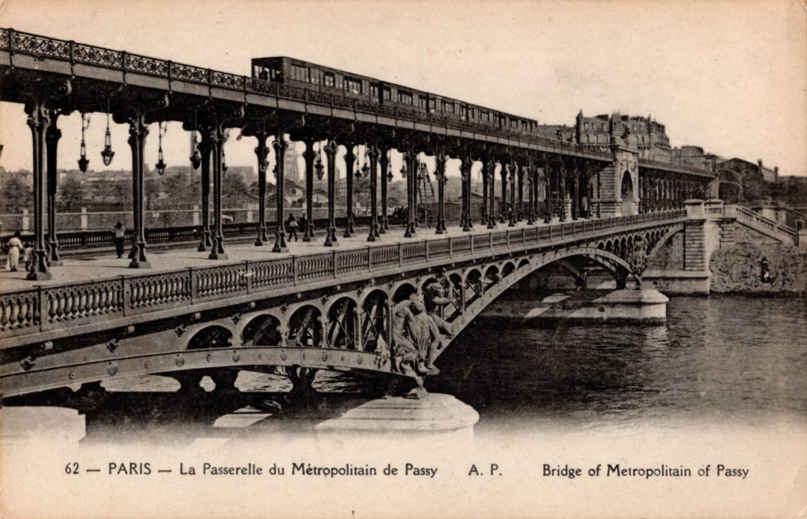
Bridges of Paris: 2 Pont de Bir-Hakeim
Pont de Bir-Hakeim links the Parisian districts of Passy (16th.) and Grenelle (15th.) and carries Métro line 6 over the Seine on one of two such crossings on its circuitous arc from Charles De Gaulle - Étoile in the west to Nation in the east. Approaching the Passy Métro station on rue de l’Alboni ends in a deep visual dive over the river Seine as if poised at the top of a ski slope. From the railings at the end of the street the view takes in the platforms and canopies of Passy station and the ribbons of steel rail leading to the next station and beyond, deep into the 15th. arrondissement. Less obvious are the bridge abutments that mark the passage over the Seine which is the reason for this spectacular view opening up.
The bridge itself is a two tier viaduct for road and rail (Métro) - in the centre of the roadway a pedestrian walkway and cycle route runs underneath the rail bridge. The railway runs on a concrete deck supported by tall slender steel columns, each formed from four plate sections that taper and flare to make them easier on the eye. There’s more beautification in the form of Classical reliefs representing Electricity and Commerce on the stone built central arch. Additional sculptures grace the steel substructure where it rests on the stone pier of the Île aux Cygnes. The bridge designer was Jean-Camille Formigé whose work can be seen all over the city on Métro infrastructure and the Viaduc d’Austerlitz. When the bridge was completed in 1905 it was known as the Viaduc de Passy – in 1948 it was renamed in honour of the Free French military victory at Bir-Hakeim in 1942.
The colonnade is a popular location for fashion photo-shoots and the bridge has made many appearances on screen, most notably in Zazie dans le Métro and Last Tango in Paris. The photos conclude with images of the elevated platforms at Métro Bir-Hakeim (formerly Quai de Grenelle).
Sunday, 18 April 2021
Postcard of the Day No. 103 Morlaix
A busy scene in the Breton market town of Morlaix where a narrow-gauge train operated by Chemins de Fer Armoricain, a metre-gauge network of lines built to connect small towns and neighbouring coastal settlements along the north coast of Finistère. The Morlaix section opened in 1912 which may well be the year of the postcard. A group of women in Breton headdress are making their way into town, passing the modest but decoratively detailed station building, complete with édicule. Above the train, the massive piers of a railway viaduct can be seen on its march across the steep sided valley in which the town is located. What we see here is just the first level of the structure which has 9 arches - the upper level is more than 60 metres in height and has 14 arches. Its presence is inescapable - it dominates the view from all districts of the town and must have been a hugely resented intrusion when it was under construction in 1861-63. The lower level incorporated a pedestrian walkway but last time I was in Morlaix (more than 10 years ago) I discovered it locked and barred in a way that suggested it was unlikely to ever reopen.
After several years of construction the viaduct was fully opened in 1865 as a vital link in the main line from Paris to Brest operated by Chemins de Fer de l’Ouest. Today, up to 7 TGV services from Paris-Montparnasse cross overhead each day and the viaduct is protected as a national monument. These postcards are a reminder of how private commercial interests could transform a townscape that had evolved over many centuries by promising connectivity and future prosperity. At the same time public perception changes from outright hostility via gradual acceptance to popular veneration as a monument to engineering achievement. The narrow-gauge railway was barely viable from the start and never generated enough traffic to pay its way - the convenience of delivering passengers to the heart of the town was offset by the lack of potential business in the sparsely populated hinterland. It closed for good in 1934 after only 22 years of service. Despite several visits to Morlaix over the years, I had no idea of its existence until I saw this postcard.